PITFs developed an online collaborative research tool that allowed students to work in teams to analyze primary sources and to create sets of searchable online notecards. Students used social computing-style tagging to annotate the cards. The Collaborative Research Tool was built using the Cake PHP framework. The user interface was updated and refined, and a larger data set of source materials was imported into the application in 2009.
... Read more about Collaborative Research Tool
 The PITFs developed a tagging ontology and optimized 2,260 video clips for progressive download.
 The goal of this project was to develop maps and guides for student research that would act as an archive for the future in order to better understand university/community relations.
 Students navigated a mosque complex using a floor plan, and could inspect photographs of each important feature. Students were able to zoom in on photographs for more detail, view annotations with important architectural terms and features, and look up terms in the course's audio glossary. These ...
 All images of artifacts were placed as markers on a Google Earth map. By clicking on the marker, you see a picture of the artifact, a description of it, and the name of the location in both English and Chinese. There was also a link that bounced back to the course website and the weekly lecture slide that corresponded with the image....
  This interactivity was intended to simulate the original viewing conditions of Duncan Grant's "Abstract Kinetic Collage" (1914). Fifteen feet long and eleven inches wide, Abstract Kinetic Collage was to be viewed through the aperture of some device as it scrolled to musical accompaniment.
 Google SketchUp was used to create a richly interactive and historically authentic 19th-century psychiatric asylum on Harvard's island in Second Life. 3D historical models of Colney Hatch and Bedlam hospitals were created. A Google Earth KMZ file was used for easy distribution and to provide supplementary information.
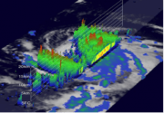
 This 3D, interactive Java Applet displayed a variety of overlying faults data sets which could be toggled on and off, along with a feature allowing the creation of a plane from three points....